Loading…
Guide to Permits for Rural Fiber Projects
By weirdtoo·July 31, 2026·11 min read
Permit checklist for rural fiber builds: federal reviews, ROW and crossings, pole attachments, construction practices, and closeout.
Guide to Permits for Rural Fiber Projects
If you miss one permit, a rural fiber build can stop cold. From the start, I’d sort the job into 4 permit groups: road and land access, federal review, special crossings and pole attachments, and closeout records.
Here’s the short version:
- Federal review often takes the longest
-
Access permits depend on where the route runs
- County roads, state highways, private land, tribal land, and rail corridors can all need separate approvals
- One rural route may cross multiple counties and agencies, not just one city office
-
Build method changes the permit path
- Open trenching has more surface disturbance
- HDD is often used at rivers, wetlands, railroads, and bridges
- Stormwater permits often start at 1 acre or more of disturbed ground
-
Aerial fiber adds another layer
- Pole attachments need owner approval
- Make-ready work can delay the schedule
- Pole loading checks are often part of the package
-
Closeout is part of permitting too
- As-builts, inspection records, route changes, and restoration proof help support final sign-off and payment
In plain English: if I were planning a rural fiber route on 07/31/2026, I’d start permit work during design, track every route segment in one register, and keep field records from day one. That cuts the risk of rejected applications, stop-work orders, and missed reimbursement.
| Permit group | What it covers | Main risk if missed |
|---|---|---|
| Access | ROW, encroachment, easements, road permits | Crews can’t enter or work in the corridor |
| Federal review | NEPA, Section 106, ESA, water/wetland review | Route delays, redesign, denied clearance |
| Special crossings | Railroad, bridge, pole attachment, water crossing | Long review times and schedule slips |
| Closeout | As-builts, inspections, restoration, records | Delayed sign-off or payment |
The core idea is simple: permit early, track by segment, and make sure field work matches the approved route.
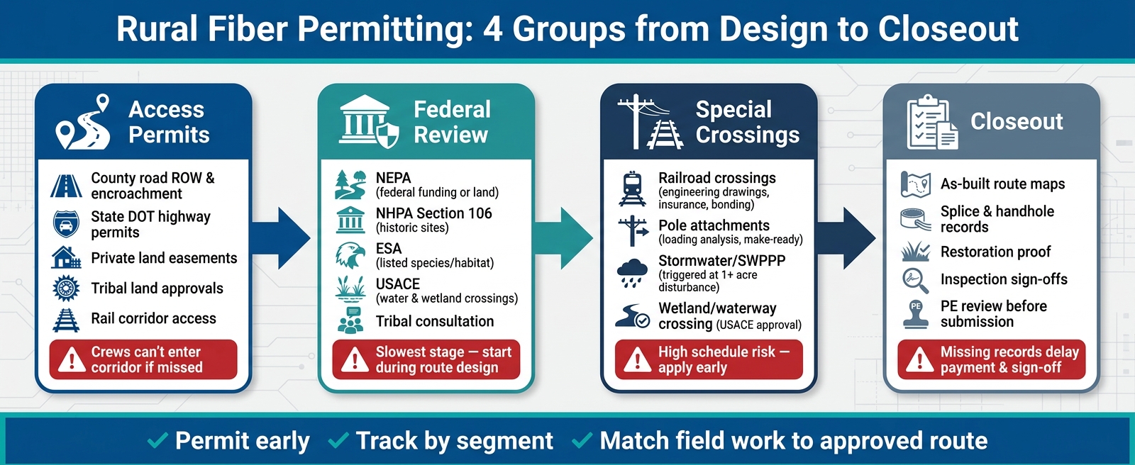
Rural Fiber Permit Process: 4 Groups from Design to Closeout
Federal Environmental and Historic Review for Rural Fiber
For rural fiber builds, the environmental track is often the slowest-moving part of permitting. If the route touches federal land or uses money from a federal program, this review needs to begin during route design and move in parallel with the rest of permitting [2][4].
NEPA Review for Federally Funded Routes and Federal Land
NEPA comes into play when a project involves federal funding or federal land. That includes BEAD, USAC-funded projects, and routes that cross land managed by agencies like BLM [2][4]. In practice, projects usually go through screening questionnaires, a Categorical Exclusion, or an Environmental Assessment.
The big takeaway is simple: build environmental review into route design from day one. If you wait, you can end up redrawing parts of the route later, which costs time and money [2][3][4].
NHPA Section 106, ESA, and Tribal Coordination
Three other federal reviews often show up alongside NEPA for rural fiber routes: NHPA Section 106, the ESA, and tribal consultation [2][4].
Section 106 applies when federal funding or a federal permit could affect historic properties or cultural resources. That usually means working with the State Historic Preservation Office (SHPO) and, when tribal interests are involved, the Tribal Historic Preservation Officer (THPO) or the tribal government directly [2][3].
The ESA applies when construction could affect a listed species or its critical habitat. In those cases, review from the U.S. Fish & Wildlife Service may be required [1].
| Review | Primary Trigger | Lead Agency | Key Focus |
|---|---|---|---|
| NEPA | Federal funding or federal land | NTIA, FCC, or the land-holding agency | Overall environmental screening |
| NHPA Section 106 | Federal undertaking affecting historic properties | SHPO, THPO, tribal governments | Historic properties and cultural resources |
| ESA | Potential impact on listed species or critical habitat | U.S. Fish & Wildlife Service | Wildlife protection and sensitive habitats |
| Clean Water Act | Crossing waterways or wetlands | U.S. Army Corps of Engineers (USACE) | Wetlands, waterways, and erosion control |
These reviews often happen at the same time. So your route maps and field data need to do more than one job. They should support environmental screening, historic review, species review, and water crossing review all at once.
Tribal consultation should start during route design, not after crews are on the calendar. Use the proper government-to-government channel, and flag tribal lands, cultural resources, and consultation areas early in the process [2][3].
Program-Specific Environmental Paperwork for Broadband Grants
Federal broadband programs add their own paperwork on top of NEPA and NHPA review. Under BEAD, subgrantees usually need to complete environmental questionnaires, submit route maps that mark sensitive areas, and show how they screened for wetlands, historic properties, and listed species before construction starts [4].
GIS can save a lot of pain here. During feasibility review, use tools like ArcGIS or QGIS to screen for wetlands, federal land, tribal areas, and archaeological zones. It’s much easier to catch a route conflict on a map than after permits are in motion [2][3].
Just as important, keep a written record of every agency approval, condition, and request. That paper trail matters for grant reimbursement audits, and it helps if a compliance issue surfaces later [3][4][5].
Once the environmental review path is clear, the route can move into rights-of-way and crossing permits.
sbb-itb-342b8b2
Rights-of-Way, Crossings, and Attachment Permits
Once environmental review clears the route, the next bottleneck is usually access and crossing permits.
County and State Road Permits for Trenching and Boring
Rural fiber routes often follow public road corridors. That means county road departments and state DOTs are usually the first stop for underground work.
If you're trenching or boring inside the right-of-way, you may need right-of-way, encroachment, excavation, or utility-cut permits. In many cases, the road agency will also ask for traffic control plans and maintenance-of-traffic plans. Those documents show how crews will keep vehicles moving and protect drivers during construction.
It’s smart to confirm permit requirements with the road agency in writing before you lock in final drawings. That small step can save a lot of back-and-forth later.
State DOT permits apply when work runs along state highways. These permits usually include encroachment paperwork plus traffic control and maintenance-of-traffic documents.
Railroad Crossings, Pole Attachments, and Conduit Access
Railroad crossings and pole attachments tend to be the most schedule-sensitive approvals. These are the permits that can quietly throw off the whole build calendar.
For railroad crossings, railroads often require:
- Engineering drawings
- Casing requirements
- Boring depth specs
- Insurance certificates
- Bonding
- Flagging services
Those items usually need to be in place before the railroad will approve the crossing, so these applications should go in early.
Pole attachments work a bit differently. Before fiber can be attached to an existing utility pole, the pole owner will usually require a pole loading analysis. If the pole can’t handle the added load, make-ready engineering or pole replacement may be needed to meet National Electrical Safety Code (NESC) requirements.
Applications are often handled through platforms like AldenOne or NJUNS. And here’s the catch: make-ready delays often push aerial schedules.
These approvals need to be secured before crews mobilize.
Construction Permits with Environmental Triggers
Grading and stormwater permits add site-level conditions to construction. Stormwater permits are typically triggered when land disturbance reaches 1 acre or more [1][2]. Once that threshold is hit, a Stormwater Pollution Prevention Plan (SWPPP) must be in place before construction starts.
The SWPPP explains how the site will control erosion and sediment runoff during the build. Put simply, it’s the playbook for keeping disturbed ground from turning into a muddy mess after rain.
Wetland and waterway crossings may also require USACE approval and engineer-stamped plans [1][2].
| Permit Type | Issuing Authority | Common Documents | Environmental Trigger | Schedule Risk |
|---|---|---|---|---|
| Right-of-Way / Encroachment | County, City, or State DOT | Traffic control plans, maintenance-of-traffic plans, construction drawings, excavation or utility-cut permit | Work within public road corridor | Low to Medium |
| Railroad Crossing | Railroad company | Engineering drawings, casing specs, insurance, bonding, flagging | Crossing or occupying railroad right-of-way | High |
| Pole Attachment | Utility or electric co-op | Pole loading analysis, make-ready engineering | Aerial fiber on existing poles | Medium to High |
| Stormwater (SWPPP) | State environmental agency | Stormwater Pollution Prevention Plan | Land disturbance of 1 acre or more | Medium |
| Wetlands / Waterway | USACE / State DEP | Site survey, environmental assessment, mitigation plan | Crossing rivers, streams, or protected wetlands | Medium to High |
Next, the build method and field practices determine how to avoid wetland, erosion, and restoration problems.
Field Practices That Reduce Risk and Permit Delays
Permits only matter if crews in the field follow them. Soil handling, water protection, and habitat limits need to match the approved route from day one.
This is the point where permit language turns into plain crew directions.
Wetlands, Waterways, Erosion Control, and Stormwater
The goal is simple: keep exposed soil out of water. That means keeping the disturbance footprint tight, working in short sections, and restoring each segment right away.
Crews need to handle spoil piles, trench dewatering, and site restoration the way the permit requires. Once a segment is done, disturbed ground should be backfilled, compacted, and reseeded as soon as possible instead of sitting bare until the next rain hits [1][3].
A pre-construction site visit helps lock this down. Photos and field sketches give crews a clear picture of where culverts, waterways, and easements are, so they can steer clear of them during work.
Wildlife Protection and Trench Safety in Sensitive Areas
Field inspections help confirm that crews stay inside ESA work limits and follow both safety rules and permit conditions [3].
Open Trenching vs. Directional Drilling
The build method shouldn't be treated like a last-minute construction call. It needs to be handled as a permit condition.
Horizontal directional drilling (HDD) cuts down surface and habitat disturbance at crossings. Open trenching fits standard roadside right-of-way segments where soil disturbance can be controlled and restoration is fairly direct.
HDD isn't risk-free, though. One of the main concerns is a frac-out, when drilling fluid reaches the surface near water. That's why bore profile drawings and depth-of-cover specs need to be detailed and followed closely to lower that risk [1][6].
| Feature | Open Trenching | Horizontal Directional Drilling (HDD) |
|---|---|---|
| Primary Use Case | Standard roadside right-of-way segments | River crossings, wetlands, railroads, bridge crossings [1][6] |
| Disturbance Footprint | High; broad surface disturbance | Low; limited to entry and exit pits [6] |
| Environmental Risk | High risk of erosion and sedimentation near waterways | Lower surface risk; monitor for frac-outs near water [1] |
| Review Burden | Standard local/state ROW permits [5] | May trigger USACE and state environmental or wildlife review [1] |
| Restoration Needs | High; backfill and restore | Minimal; primarily entry/exit point repair |
Record the selected method and its restoration needs in the permit register. Then track those method-specific limits before crews mobilize.
Permit Tracking, As-Builts, and Final Compliance Closeout
Permits only matter if you can prove compliance during construction and at closeout. Once the build begins, the permit register becomes the control center for compliance, inspections, and final sign-off.
Build a Permit Register Before Construction Starts
A permit register is a central record that tracks every approval across each corridor and jurisdiction on the route. Set it up before construction starts.
It should track permit type, approving authority, route segment, dates, conditions, dependencies, inspection status, and expiration.
Here are the core categories to include:
| Register Category | Essential Fields |
|---|---|
| Administrative | Permit ID, jurisdiction/agency, route segment, responsible internal lead |
| Status/Dates | Submission date, approval date, expiration date, current status |
| Compliance | Permit conditions, environmental triggers, revision history, mitigation requirements |
| Field/Closeout | Inspection status, restoration proof, as-built submission date, final sign-off |
| Contacts | Agency decision-maker name, phone/email, vendor/contractor contact |
Scattered emails and disconnected spreadsheets are where deadlines slip. A centralized, indexed register makes multi-county routes far easier to manage [2][5].
For BEAD-funded or other federally backed projects, this register also becomes a key record for reimbursement requests and audits [4].
Record As-Builts, Restoration Proof, and Inspection Records
When fieldwork ends, as-builts become the record of what was actually built.
Closeout records show that the build matched the approved route. The core package includes route maps, splice and handhole locations, change logs, and final inspection sign-offs [3][6].
If the field team made changes, document them. When as-builts don’t match the approved design, acceptance can stall [3].
For aerial segments, include attachment height sheets and pole loading analysis. For bore segments, keep bore profile drawings and field photos [5][6]. A Professional Engineer (PE) review of as-built documentation before final submission can catch field issues before closeout [1].
Conclusion: Permitting Works Only When Tracking, Field Records, and Closeout Stay Aligned
Closeout is the last compliance check. Rural fiber permitting works best when it runs as a structured process, not a last-minute paperwork scramble.
Build the register first. Keep it current. Document field changes as they happen. Carry complete records through closeout.
Projects close cleanly when permitting stays active through construction.
FAQs
Which permits usually take the longest?
The longest delays usually come from permit reviews tied to NEPA and NHPA, along with Right-of-Way (ROW) agreements. Utility pole attachment approvals can drag things out too.
To keep things moving, teams usually lean on a few core tools:
- Feasibility studies
- Detailed engineering drawings
- A permitting matrix to track approvals and milestones
That mix helps teams spot roadblocks early and stay on top of each step instead of waiting for delays to pile up.
When should permit work start on a rural fiber project?
Permit work needs to start early. In rural fiber projects, teams often have to coordinate with local, state, and federal agencies, and that process can take time.
The main areas to plan for are ROW access, utility pole attachments, and compliance work tied to NEPA documentation and Section 106 review. It also helps to track permit requirements closely from the start and plan for obstacles such as waterways and railways.
What records should we keep for permit closeout?
Keep audit-ready records that show compliance across local, state, and federal permits. That includes environmental and historic preservation requirements such as NEPA and Section 106.
You should also include documentation tied to:
- Right-of-Way access
- Tribal consultations
- Local ordinances
- Any federal grant requirements tied to the project
The goal is simple: if someone reviews the file later, they should be able to see what was required, what was completed, and how the project stayed in line with each rule.
Current contact path
Need Weird Network WiFi, custom apparel, or scoped help?
Use the contact form; removed product, checkout, research, and newsletter funnels stay offline.